Id-ee85778a-284c-cb43-73be-7ce2d4e35c50: verschil tussen versies
| Regel 10: | Regel 10: | ||
<br/> | <br/> | ||
[[Bestand:Bodemval symbool Arcgis.png|300px]] | [[Bestand:Bodemval symbool Arcgis.png|300px]] | ||
| − | |Bron=DAMO | + | |Bron=DAMO objectenhandboek |
|Exacte overeenkomst=https://damo.hetwaterschapshuis.nl/DAMO%201.3/Objectenhandboek%20DAMO%201.3/HTML/DAMO%20Watersysteem%20Objectenhandboek.html?bodemval.html | |Exacte overeenkomst=https://damo.hetwaterschapshuis.nl/DAMO%201.3/Objectenhandboek%20DAMO%201.3/HTML/DAMO%20Watersysteem%20Objectenhandboek.html?bodemval.html | ||
|Gerelateerd=Id-0f6895db-6841-4b99-ae1d-36b0f1ad1c8b | |Gerelateerd=Id-0f6895db-6841-4b99-ae1d-36b0f1ad1c8b | ||
}} | }} | ||
Huidige versie van 10 dec 2021 om 12:20
Eigenschappen
| Label (nl) | bodemval |
|---|---|
| Type symbool | GIS |
| Codering | Kunstwerk symbolen Aquo TTF Unicode 55 |
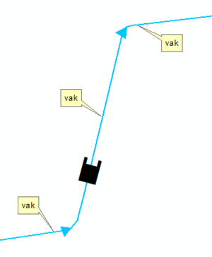
| Definitie (nl) | Het symbool wordt midden op het kunstwerk geplaatst in de lengterichting van de waterloop, opening is uitstroomzijde. |
| Afbeelding van |
 |
| Bron | DAMO objectenhandboek |
| Exacte overeenkomst | https://damo.hetwaterschapshuis.nl/DAMO%201.3/Objectenhandboek%20DAMO%201.3/HTML/DAMO%20Watersysteem%20Objectenhandboek.html?bodemval.html |
Relaties
| Vertrekpunt | Relatie | Eindpunten |
|---|---|---|
| bodemval | Gerelateerd |
|
